


Data, with its wealth of untapped potential, is now seen as the “new oil” that is growing a new industrial revolution. How can we prepare our children for it?
Mobile applications like Google™ maps, Waze, Grab and Mytransport have made our lives more convenient and efficient. They depend on the use of a Geographical Information System (GIS), which is a computer software that allows the study and manipulation of data in a digital map format.
Today, there is a growing number of companies tapping into the GIS market and specialising in selling GIS solutions similar to Google™ maps. This development in GIS is part of a growing global data industry that is set to ‘disrupt’ existing ways of producing and selling goods and services.
For example, Microsoft set up data analytic units to design software to work with different types of data, including those typically seen on digital maps. Businesses use these software to understand and even predict what consumers want. These days, shopping apps can alert shoppers to real-time sales in nearby shopping centres.
In Singapore, the Singapore Land Authority uses OneMap.gov.sg to offer location-based services. The button, School Query, helps parents to search for schools nearby using their home addresses.
Going digital in the Geography classroom
As students prepare for a knowledge-based economy, they need to be digitally ready. That means having access to digital technology, knowing how to use it and being able to create with it.
To that end, secondary students have been given opportunities to dip their toes into the water, and experience the potential of GIS. They learn to read and create digital maps in a GIS environment, and find out how and why information is represented as such.
Lower secondary students of Bedok Green Secondary School recorded their Global Position System (GPS) co-ordinates as they collected water samples at Bedok Reservoir for testing. Subsequently, they used a customised digital map to study the data, which helped them understand geographical concepts of place, space and scale simultaneously.

Students classified the trees they saw into 3 categories (represented as red or green symbols of different sizes) and used temperature values to represent the size of the symbols.
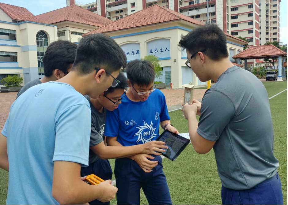
At Presbyterian High School, upper secondary students who investigated the relationship between temperature and ground cover used a mobile survey app, Survey123, to map their GPS co-ordinates as they collected field data. They scoured the school grounds and neighbourhood to record the types of surfaces, such as concrete, grass, and rubber, and the amount of tree cover. This data for their geographical investigation was saved in the app for further analysis.
“Students get visualisations straightaway in a clear manner using professional GIS software like ArcGIS Online and Google EarthTM,” said Mr Tan Chai Choon, a Geography Senior Teacher at Bedok Green Secondary School.
Teachers have found it helpful to have information presented on a digital map, as students could observe patterns and infer possible correlations.
“The visual nature of GIS data helps students better appreciate the scale of flood events resulting from sea level rise,” said Ms Cheri Nur Aini, a Geography Teacher at Presbyterian High School, who actively used GIS map resources to stimulate students’ interest in flooding events.
A first exposure to GIS in secondary Geography learning helps to pave the way for students. Polytechnics, such as Nanyang Polytechnic, have included GIS training for students in their Infocomm Technology (ICT) diploma courses to prepare them for future employment as they observe the demand for GIS trained graduates. Students interested in pursuing geospatial training at the undergraduate and postgraduate level can take on GIS focused modules or even a Master of Science in Applied GIS at the National University of Singapore. Singapore Land Authority has also partnered 8 other public agencies to offer the Singapore Geospatial Scholarship to students interested in geospatial-related careers.
Engaging your child with GIS
With the prevalence of mobile apps that utilise GIS, anyone with a smartphone can have fun with it with their child. Digital maps are a simple starting point. For example, you can use StoryMaps to discuss the 2018 World Cup with your teenager.
For younger children, try using OneMap.sg as you show them the neighbourhood and talk about routes between school and home or their favourite playgrounds to increase their awareness of their surroundings. Let your child draw his or her own maps of the neighbourhood or school on paper or in a drawing software or mobile app and talk about what matters to them in these maps. Enjoy the discussions!


